Author Archive

The Ohio River Basin Alliance – Working for Healthy and Productive Ecosystems

Over the last two articles, I introduced you to the Ohio River Basin Alliance (ORBA) and presented ORBA’s strategies to make sure we continue to have abundant clean water. In this article, I’m going to discuss ORBA’s plans to maintain the basin’s healthy and productive ecosystems.

DLZ employee conducts water quality testing along the Portage Creek, as part of a study to improve the area’s ecosystem

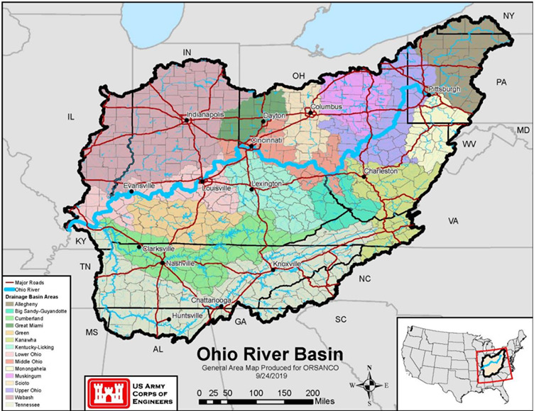
First, let’s talk about how diverse our ecosystems are in the Ohio River Basin. Did you know the Ohio River and its tributaries are home to 164 species of fish and over 100 species of mussels? The Ohio River Basin is very large and covers an area of 200,000 square miles with about 7,000 miles of waterfront along the Ohio River and its main tributaries. The Basin is nationally and internationally renowned for its diversity of ecoregions that distinguishes it from other basins within the United States. As shown on the map below, portions of 16 different ecoregions are found within the Basin making it one of the most diverse and productive regions in the nation. In fact, the Green, Tennessee, and Cumberland River sub-basins are among the richest ecological regions in the world based on species diversity.

Source: U.S. Army Corps of Engineers

Although rich in diversity, human activity has led to the loss of wildlife habitat that negatively impacts native wildlife populations. Of the 127 mussel species once found in the Ohio River, 11 are now extinct and 46 others are threatened, endangered or a species of concern.

Also, unfortunately, non-native invasive species are moving into the basin every year and threatening our native species. Invasive species already present in the basin include Asian carp, zebra mussels, emerald ash borer, and kudzu. These invasive species are capable of outcompeting native species for resources, altering ecosystem functions, and causing disease, and remarkably their impacts cost billions of dollars to the nation’s economy each year. Typically, invasive species often grow faster, disperse over larger areas, and have few natural predators so they can outcompete native species, reduce biodiversity, degrade water quality, and negatively affect our recreational, commercial, and agricultural activities.

The condition of our soil also has a profound impact on our ecosystems as well as water quality. Presently, our soils along with their nutrients are being eroded from farmlands at a greater rate than it can be replenished. Improving the health of our basin’s soil for water infiltration is an effective way to decrease runoff and improve moisture content and nutrient retention for healthy crops.

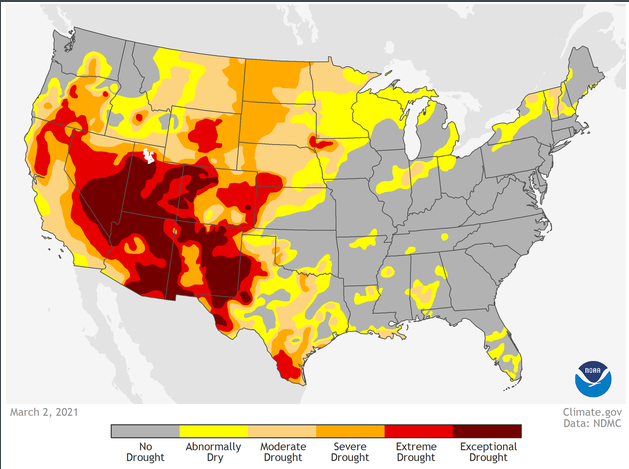
One of my last projects with the U.S. Army Corps of Engineers was a pilot study that evaluated the impacts of climate change on the Ohio River Basin. According to the climate change models conducted during the study by the National Weather Service, the average temperature is expected to rise a half-degree per decade from 2011-2040 and a full degree from 2041 to 2099. This rise in temperature causes changes in precipitation, which of course, impacts flows. The changing patterns in our precipitation will create more challenges for not only maintaining our ecosystems but also for agriculture, industries, and communities that need reliable water sources.

So How Do We Maintain Healthy and Productive Ecosystems?

As part of the strategic plan for the Ohio River Basin, there are three main objectives for maintaining and enhancing our ecosystems.

Objective 1: By 2022, basin states, conservation organizations, the USEPA, ORSANCO, and other stakeholders will work together to develop a plan to improve the basin’s ecosystem through the identification of at-risk ecosystems and the threats to them such as acid mine drainage and emerging toxic contamination.
Strategic actions that ORBA stakeholders plan to take to meet this objective would be to facilitate coordination among The Nature Conservancy, the US Fish and Wildlife Service, the National Wildlife Federation, the Ohio River Basin Fish Habitat Partnership, the Southeast Aquatic Resources Partnership, and other stakeholders to develop and restore the basin’s aquatic ecosystem.

Objective 2: By 2025, secure funding to initiate a federal geographic program to restore the basin that meets the needs of the states, the USEPA, ORSANCO, and other stakeholders.
Basin stakeholders would establish an Ohio River Basin Restoration Initiative using guidance from similar restoration initiatives such as the Chesapeake Bay Restoration Program, the Columbia River Restoration Program, and the Great Lakes Restoration Initiative. They would also work to restore floodplains and protect existing high-quality habitats and native aquatic populations. In addition, they would expand upon the Natural Resource Conservation Service’s existing Mississippi River Basin Healthy Watersheds Initiative to pursue a healthy soil initiative to protect farmlands and improve erosion control, water retention, and fish and wildlife habitat.

Objective 3: Implement strategies to eradicate, control, and manage invasive species utilizing sound scientific data and effective control methods. Also develop and implement education and outreach programs to increase the understanding of the negative impacts of invasive species.
ORBA will advocate for existing organizations like the Aquatic Nuisance Species Task Force to develop and implement a basin-specific program to study, monitor, and control invasive species. It will also advocate for basin funding in 2021 for the Asian Carp National Plan.

Next time we’ll look at the 3rd goal – performing research and improving education so the public and decision-makers can make informed decisions. If you’d like to join ORBA, contact Dr. Harry Stone at hstone@orsanco.org.

The Ohio River Basin Alliance – Working for Abundant Clean Water


In the first Ohio River Basin blog series, I shared an overview of the Ohio River Basin Alliance (ORBA). ORBA is a volunteer group of more than 130 organizations that are working together to sustain healthy ecosystems along the Ohio River and its tributaries and to improve our water-dependent economies.

Since the first Ohio River Basin Summit in 2009, in Covington, Kentucky, there have been 11 summits in 5 states where ORBA members worked to develop goals for the Basin to ensure the quality and quantity of our water will support our environment and local economy. Recently, the U.S. Army Corps of Engineers Louisville District released a study entitled, “Plan for the Ohio River Basin 2020 – 2025”. The purpose of the study was to create a basin-wide strategy that identifies goals, objectives, and actions for improving the ecological well-being, economic health, and quality of life for residents throughout the basin.

In this blog, I will focus on the first goal – ensuring we have abundant clean water.

Fortunately, we who live in the Ohio River Basin live in a water-rich region. Talk to residents in the southwestern states and you’ll understand what an environmental, and economic asset that is. NOAA’s recent drought projection shows extreme and exceptional drought projections for most of the southwest for the coming year.

The categories shown along the bottom of the map reflect how much water is available in streams, lakes, and soils compared to normal amounts for this same time of year. The darker the shade on the map, the more intense the drought conditions. You will notice that the Ohio River Basin is not expected to have drought conditions this year, so we should have enough water to sustain our ecosystems, agricultural industry, and local economies that depend on it. That may not be the case for many of the southwestern states.

Abundant Clean Water

Federal, state, and local agencies have made significant progress in improving water quality in the Basin since the passage of the Clean Water Act in 1972; however, much work still remains to address non-point source pollution, legacy contamination, and contaminants of emerging concern. Water quality and water quantity monitoring are critical in making informed decisions. Expanding the number of gaging stations throughout the Basin will be an important step in managing our water resources in the future. Already realizing this, the USGS has been increasing the number of its gaging stations in the basin over the last ten years.

On the bright side, collectively, ORBA stakeholders have the expertise and experience required to address these water quality and water quantity challenges. The strategic plan lays out a plan for them to work together to accomplish the following five objectives by 2025.

Objective 1: Organizations will work together to increase the number of water bodies in the Basin that meet the Clean Water Act’s standard in 2030 compared to 2020.

Strategic actions that ORBA stakeholders would like to take to meet this objective would be to develop a comprehensive GIS database to support Clean Water Act initiatives and inventory acid mine sites, coal ash ponds, and underground mine pools. Once these sites are inventoried, stakeholders would develop a reclamation strategy to clean up ten high-priority sites. Other steps would be to support agencies’ efforts to implement Clean Water Act requirements through improved water quality standards as well as supporting agencies’ efforts to monitor and assess health risks due to contaminants of concern. Another action would be to expand the number of USGS gages to improve water quality and water flow information.

Objective 2: Develop strategies to enhance current source water protection programs to meet the Safe Drinking Water Act requirements and support organizations that currently do not have source water protection programs.

Actions that ORBA can take to meet this objective are developing a GIS platform to map source water protection areas, listing contaminant source inventories and contaminant spill locations, and other water protection risk zones. It can also expand ORSANCO’s Ohio River Organics Detection System to respond to spills that may impact the Ohio River and its tributaries. Furthermore, it can work with ORSANCO to build water protection strategies for all water bodies in the Basin that serve as a drinking or industrial water source.

Objective 3: Identify water bodies in the Basin with high incidences of harmful algal blooms (HABs) and help stakeholders develop responses to reduce the number of occurrences between 2020 and 2030.

To address this objective, ORBA can develop a GIS platform to map waters that have HAB occurrences in an effort to achieve a reduction in HAB events. They can also support monitoring and response strategies of other organizations to maintain safe recreation and drinking water. In addition, ORBA can identify and inventory point and non-point nutrient sources and work to reduce nutrient contributions into the Ohio River Basin waters.

Objective 4: The Ohio River Valley Water Sanitation Commission (ORSANCO) will assemble water quantity managers from across the basin to identify problems affecting water quantity and recommend strategies to address water shortages.

ORBA can develop a GIS platform to map flood risk areas, drought mitigation planning areas, and water supply deficit or surplus areas. Other actions would be to expand the USGS stream gage network to measure flows in the Basin’s streams more accurately and improve hydrologic and hydraulic models to see how our infrastructure will handle expected climate changes.

Objective 5: Inventory drinking and wastewater system infrastructure needs across the Basin and develop a strategy to maintain these systems.

For this objective, ORBA could develop a GIS platform to inventory drinking and wastewater infrastructure needs in the Basin and work with the USEPA to address these aging assets.

Of course, to do all this work requires funding, so securing the financial resources to take these actions is paramount. Next week we’ll look at the 2nd goal – how we can enhance the Basin’s ecosystems to support the natural habitats and fish and wildlife that depend on them.

What is the Ohio River Basin Alliance (ORBA)?

The Ohio River Basin Alliance (ORBA) is a volunteer group of stakeholders who work together to set water resource priorities for the Ohio River Basin to sustain healthy ecosystems and communities and improve our water-dependent economies.

ORBA provides a forum for addressing water resource issues in the Ohio River Basin in today’s changing environment. ORBA includes members from over 130 organizations, including local, state, and federal agencies, commissions, industry, academia, and not-for-profit organizations.

How It All Started

In 2009, in addition to serving as Commander of the U.S. Army Corps of Engineers Great Lakes and Ohio River Division in Cincinnati, Major General John Peabody also served on the Mississippi River Commission. The Commission’s purpose is to improve navigation and prevent destructive floods on the Mississippi River. Knowing the vital role the Ohio River plays for the nation, General Peabody investigated the possibility of forming a similar commission to oversee the Ohio River. He learned there had been an Ohio River Commission prior, but it was abolished during the Reagan Administration to downsize the federal government. General Peabody knew it would be an uphill battle for Congress to re-establish the commission. He thought the next best thing to do would be to assemble representatives from various stakeholders from all backgrounds and interests within the basin to discuss the basin’s needs and set priorities.

That is where I came in.

I worked at the Huntington District Corps of Engineers and served as the Corps’ Liaison to the State of Ohio and the U.S. Department of Energy’s National Energy Technology Laboratory. Because of my experience in building collaborative relationships, I was asked to establish a stakeholders’ group for the Ohio River Basin in Cincinnati. The basin is large, which many people don’t realize. It covers over 204,000 square miles, is home to 25 million people, and includes 15 states stretching from New York to Alabama.

Source: U.S. Army Corps of Engineers

Our first meeting, called “The Ohio River Basin Summit,” was held in 2009 in Covington, Kentucky, across the Ohio River from Cincinnati. Sitting in a conference room overlooking the river, a group of nearly 100 stakeholders agreed to form a volunteer group and work together to set priorities to improve the basin’s environment and economy. This group came to be known as the Ohio River Basin Alliance, or ORBA.

Initially, ORBA was co-led by the Corps of Engineers, the Ohio River Valley Water Sanitation Commission (ORSANCO), and the U.S. Environmental Protection Agency. Some stakeholders were unsure of the purpose of ORBA. Many thought it was a Corps of Engineers’ effort to gain more power over water resources in the basin. But over time, the parties built mutual trust and worked together to complete the first study to create a basin-wide strategy in a report “Plan for the Ohio River Basin 2020-2025.”

ORBA’s Goals

ORBA has established six main goals to ensure the quality and quantity of our water will support the environment and the economy.

  1. Abundant Clean Water: Ensure the quality and quantity of water in the Ohio River Basin is adequate to support the economic, social, and environmental functions that are dependent on it.
  2. Healthy and Productive Ecosystems: Conserve, enhance, and restore ecosystems within the Ohio River Basin to support natural habitats and the fish and wildlife resources that depend upon them.
  3. Knowledge and Education to Inform Decisions: Ensure that research and education adequately inform Ohio River Basin-wide economic, social, and environmental decisions; enhance the profile of education organizations in the Basin that synergize efforts to garner effective public involvement in the stewardship and management of the Basin’s resources.
  4. Nation’s Most Valuable River Transportation and Commerce Corridor: Provide for safe, efficient, and dependable commercial navigation within the Ohio River Basin to ensure a competitive advantage for our goods in global and regional markets; sustain a water use system to efficiently and effectively support agricultural, industrial, and energy productivity.
  5. Reliable Flood Risk Management: Provide reliable flood risk management through well-managed and maintained infrastructure, including appropriate floodplain connections for water conveyance and ecosystem benefits, and management of surface and stormwater runoff to protect life, property, and economies better.
  6. World-class Nature-based Recreation Opportunities: Enrich the quality of life for people and recreation-based economies by maintaining and enhancing riverine, lake, and wetland-associated recreation within the Basin.

Plan for the Ohio River Basin

Recently, the Corps’ Louisville District, in collaboration with ORSANCO and ORBA, released the first basin-wide strategy to create a blueprint of goals, objectives, and actions through 2025 for improvements in economic health, ecological well-being, and quality of life for those of us living in the basin.

In this blog series, I’ll describe ORBA’s strategies and action steps to meet the goals. Next week I’ll present ways we can work together to achieve the first goal of ensuring we continue to have abundant clean water.

How May Climate Change Affect the Future of the Ohio River Basin?

One can argue whether or not global warming is occurring, but facts prevent the argument that our climate is not changing. For example, this was the first year on record for three hurricanes to hit the U.S. at Category 4 or greater – Harvey (category 4), Irma (category 5) and Jose (category 4). In addition, Houston has had a 500-year flood event each of the last three years. The probability of three successive 500-year flood events is 0.000000008. In the national media we often hear how climate change will impact the coastal states, but how will it affect us here in the Ohio River Basin? I had the privilege of being the Project Manager for a recent study that was the first comprehensive study to evaluate the impacts of climate change on the Ohio River Basin’s water resources infrastructure and its ecosystem. It was conducted by a team of engineers and scientists from the U.S. Army Corps of Engineers (USACE), USEPA, the National Weather Service’s Ohio River Forecast Center, U.S. Geological Survey (USGS), Marshall University, the University of Cincinnati, the University of New Hampshire, The Nature Conservancy, and several consulting firms.

The study was led and funded by the USACE, which has a compelling need to understand and adapt to climate change because our nation’s water resources infrastructure represents tremendous federal investment that supports public safety and local and national economies. In an effort to gain a better understanding of how climate change could impact the nation’s water resources infrastructure and our ecosystems, the USACE conducted 19 climate change pilot studies across the U.S. to test new ideas and develop new information needed to develop national policy and guidance. One of these pilot studies was conducted on the Ohio River Basin.

The Ohio River Basin contains a multitude of reservoirs, locks and dams, power generation plants and other types of infrastructure that depend on sustainable water resources. In addition, ecological resources in the basin include numerous federally-protected species that may be at risk from climate change. The two primary purposes of the study were to investigate how climate change could impact water resources infrastructure (locks, dams, levees, etc.) and the potential effects of climate change on the basin’s aquatic and terrestrial ecosystems and threatened and endangered species.

The Ohio River Basin is over 204,000 square miles and covers all or parts of 14 states stretching from New York to Alabama. It is home to 27 million people, five million of which rely on the Ohio River for drinking water. Water resources in the basin provide $1.5 billion to the nation’s economy each year.

The study was based on a global climate change model produced by the International Panel on Climate Change and adapted by an interagency water resources group comprised of four federal government entities, including the USGS and the National Oceanic and Atmospheric Administration. The Ohio River Forecast Center (ORFC) modeled mean air temperature and average precipitation over three 30-year periods: from 2011-2040, from 2041-2070, and from 2071-2099 at 25 gage points throughout the basin. However, before conducting these out-year simulations, the ORFC back-casted the model for the period from 1952-2001. Remarkably, the output data for temperature and stream flows from the back-casted model was within 2% of observed historical readings in all 25 data points throughout the basin. Therefore, the model was calibrated very accurately.

The model predicted there will be little change in air temperature and precipitation from 2011-2040. However, from 2041 to 2099, the northeastern and eastern portions of the basin will experience greater rainfall and river discharges. Specifically, as much as 35%-50% greater stream flows during the spring within the Allegheny, Monongahela, Kanawha and Big Sandy River sub-basins. During this same period, the northwestern and western portions of the basin also will experience greater rainfall and river discharges in the spring season, but the fall season will bring significant reductions in rainfall and thus decreased river flows and possibly drought. The model predicted as much as 25%-35% less flows during the fall within the Great Miami, Wabash, East Fork of the Wabash, White, Scioto and Muskingum River Basins.

In summary, between 2011-2040 the mean, maximum and minimum flows are within the historical range. However, from 2041-2099 the minimum flows are likely to decrease in the fall and peak spring floods are likely to increase. The good news is we have about 20 years to take action to plan for and minimize the potential negative impacts to our basin due to climate change.