Construction Safety Week is an opportunity to refocus on hazards that affect us every day. One of the most frequent and preventable injuries across our work is hand and finger injuries. Our hands are involved in nearly every task—handling tools, setting survey equipment, loading vehicles, placing traffic control devices, lifting materials, and working around active construction operations.
Because our hands are always in use, they are often closest to hazards such as pinch points, sharp edges, moving equipment, live traffic, and repetitive tasks. Protecting our hands requires planning, awareness, and deliberate work practices, not just gloves.
Common Hand Hazards in Our Work
Pinch points when setting up tripods, adjusting equipment, opening tailgates, or handling barriers
Cuts and abrasions from stakes, rebar, metal edges, vegetation, and broken materials
Struck by hazards when handling tools, hammers, or materials near others
Hand injuries while working near traffic (cones, signs, barricades, truck doors)
Caught between hazards around moving or rotating equipment
Improper tool use (using tools not designed for the task)
Repetitive motion and fatigue leading to reduced grip and awareness
Key Hand Safety Expectations
Plan the Task
Think about hand placement before starting work
Identify pinch points and sharp edges during the Job Hazard Analysis (JHA)
Plan safe material handling and tool use
Use the Right Tools
Select tools designed for the task
Never improvise or defeat guards
Keep tools in good condition
Wear the Right-Hand Protection
Use task specific gloves suited to the hazard
Replace worn, torn, or contaminated gloves
Remove gloves only when required for precision—and only when safe to do so
Maintain Situational Awareness
Keep hands clear of moving parts
Watch for vehicle movement when placing or removing traffic control devices
Communicate with coworkers before moving materials
Don’t Rush
Most hand injuries happen when we rush or take shortcuts
Slow down, especially when conditions change
Our hands are essential to everything we do—at work and at home. Protecting them requires planning, awareness, proper tools, and personal responsibility. During Construction Safety Week, and every week, we commit to working deliberately and protecting our hands on every task.
As a significant winter storm heads toward the Midwest, it’s important to prepare for rapidly changing road conditions. Snow, ice, and freezing temperatures can make even familiar routes more hazardous. Whether you’re commuting to the office, heading to a project site, or traveling between meetings, taking a few extra precautions can make all the difference in keeping yourself and others safe.
Winter Driving: Slow Down & Stay Aware
Cold-weather road conditions can shift quickly—clear pavement can turn slick, bridges can freeze unexpectedly, and visibility can drop without warning. As this storm approaches, remember: patience and preparation are your best defenses.
Essential winter driving tips:
Reduce your speed and leave extra stopping distance—at least three times more than usual.
Brake gently to avoid skidding. If your wheels begin to lock, ease off the brakes.
Know how to handle a skid: Don’t panic. Don’t slam the brakes. Take your foot off the gas and steer in the direction you need the vehicle to go.
Turn on your headlights to stay visible in snow and low-light conditions.
Keep headlights and your windshield clear of snow and ice.
Watch for bridges and overpasses, which freeze before other road surfaces.
Don’t assume four-wheel or all-wheel drive can handle all conditions.
Keep emergency items on hand—jacket, hat, gloves, and other essentials.
Always check weather, road conditions, and traffic before heading out.
Ensure your vehicle is well-maintained with properly inflated, winter-ready tires.
Slowing down, giving yourself more time to brake, and staying aware of changing weather can dramatically improve your safety during winter storms.
Avoiding Distracted Driving: Stay Focused Behind the Wheel
Today’s vehicles are packed with technology, and our phones demand our attention constantly. During hazardous winter conditions, distractions become even more dangerous.
Studies show:
Drivers talking on the phone are five times more likely to have an accident.
Drivers who text are 23 times more likely to be involved in a crash.
Distractions impact you in three ways:
Visual – Eyes off the road
Mechanical – Hands off the wheel
Cognitive – Mind off driving
If you’ve ever suddenly realized you don’t remember the last few miles you drove, you’ve experienced how easily attention can drift.
Tips for staying focused:
Wrap up calls and loose ends before leaving the office.
Avoid heavy traffic times when possible.
Drive only as fast as the weather and road conditions allow.
If you must use your phone, pull over safely first.
Pre-set GPS destinations before driving.
Wear your seat belt at all times.
Stay alert, drive defensively, and anticipate hazards.
Avoid other vehicles’ blind spots.
Maintain a safety cushion by keeping your distance.
Safe drivers are constantly scanning the road, predicting hazards, and preparing to react—skills that become even more critical during winter weather.
As we maneuver through winter weather, staying cautious, alert, and prepared is essential. Winter driving demands patience, awareness, and respect for the conditions. By staying focused and eliminating distractions, you greatly reduce the risk of accidents.
As Wilma Mankiller said, “The secret of our success is that we never, never give up.” Let’s stay committed to safety—on and off the road.
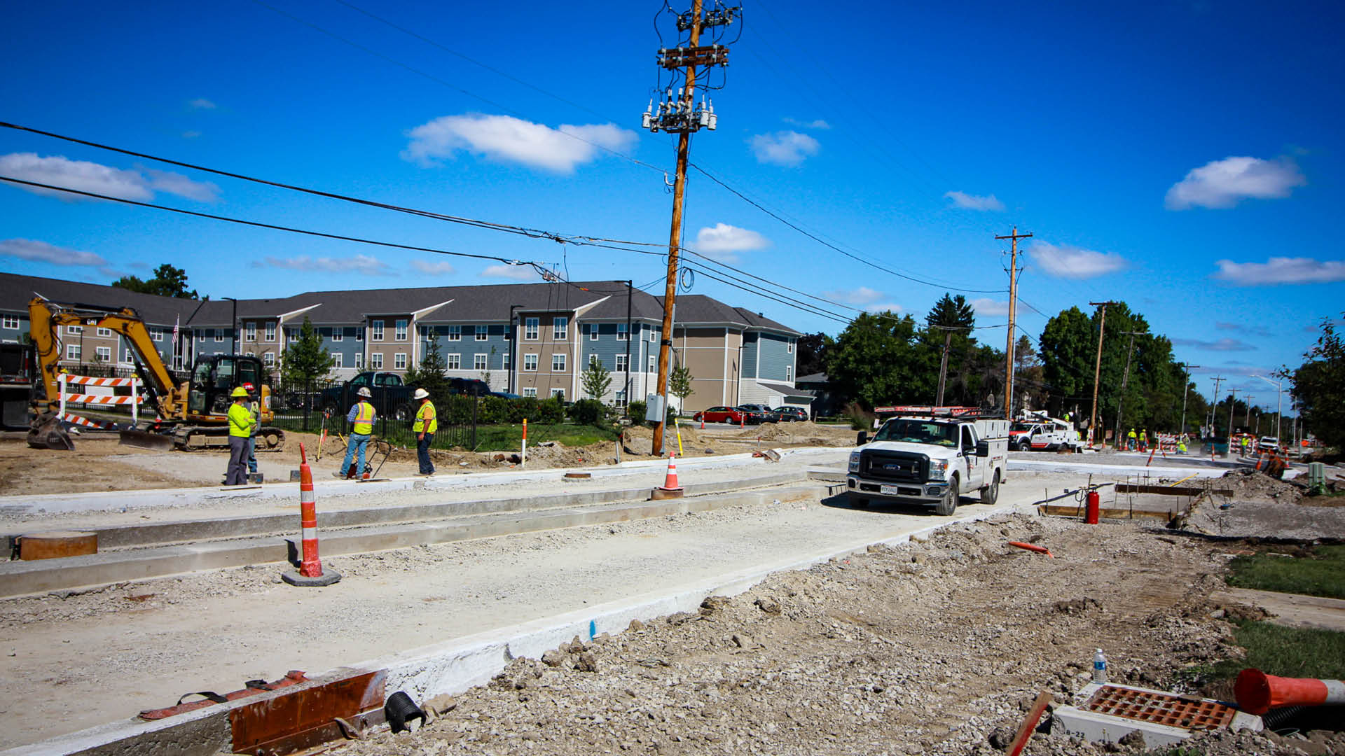
This unique project utilized medians and fully mountable mini roundabouts in an essential urban corridor to improve safety while minimizing right-of-way impacts for the City of Columbus.
HISTORY
In the 1970s, the SR 161 corridor was widened and improved to its current configuration. SR 161 is a rapidly developing area, so to safely handle its projected traffic, improvements included modern ideas in access management, including medians and service roads close to mainline SR 161. The service road intersections along the SR 161 corridor are only separated by 60-70 feet, far short of the 300’ separation recommended by the National Cooperative Highway Research Program. The pair of service road intersections, in addition to the SR 161 intersection, created three closely spaced intersections with 96 total vehicular conflict points. As this area continued to develop, it became obvious that increasing traffic and service road intersections too close to SR 161 created a safety concern. Because of these safety concerns, the City of Columbus selected DLZ to prepare a corridor study, the State Route 161 Corridor Study (PID 97169). This study helped produce six short-term improvements and four long-term alternatives.
ALTERNATIVES
The short-term alternatives included an education plan, an enforcement zone, minor signal modifications, and ‘do not block the box’ intersection signs. One other constructed, short-term alternative included placing a queue cutter traffic signal at the end of the service road. This traffic signal provided a red light at the intersection of the Service Road with Cleveland Avenue to allow traffic entering Cleveland Avenue to cut across four lanes of traffic stopped by this signal and safely enter the southbound left turn lane. The long-term alternatives for the study included maintaining two-way operation on service roads with medians and mini roundabouts, relocating the service road intersections further from SR 161, placing cul-de-sacs at the end of the Service Roads, placing mid-block right in/right out for access, and removing left turn lanes and installing mid-block r-cuts.
PREFERRED ALTERNATIVE
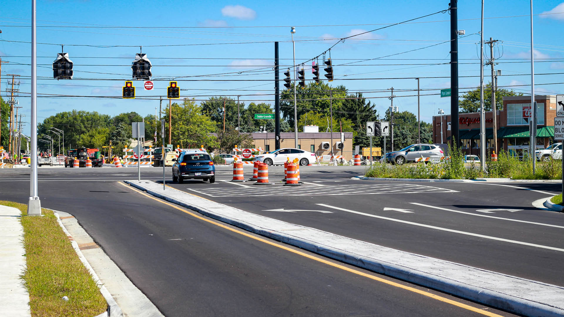
Based on the study’s results and feedback from stakeholders and the public, the preferred long-term alternative was to maintain 2-way operation on the service roads with medians on the side streets and mini-roundabouts to drastically decrease conflict points. Maple Canyon Avenue was selected to improve first because of its #3 ranking on the Mid-Ohio Regional Planning Commission’s (MORPC) yearly “Top 40 Regional High Crash Locations” list.
WHY USE MINI ROUNDABOUTS
Using traditional roundabouts in this highly developed urban area would damage property significantly. With these being the first mini roundabouts designed in the City of Columbus, DLZ visited numerous mini roundabouts in Ohio and Michigan to observe their performance, evaluating many sizes of mini roundabouts, from 70’ ICD (Inscribed Circle Diameter) to 100’ ICD. Many design vehicles like passenger cars, semi-trucks, school buses, delivery trucks, and fire trucks were also evaluated, and to balance improved traffic operations with property impacts, Columbus selected a 90’ ICD. Columbus laid out this design in a parking lot and drove fire trucks and garbage trucks through the layout to ensure this mini-roundabout concept could accommodate the different vehicles. Medians were meticulously placed through the side streets to prevent through and left-turning movements. DLZ performed a queuing analysis to ensure traffic waiting at the SR 161 traffic signals would not back up into the mini roundabout. This location also includes the new Columbus Fire Station. A signal pre-emption for the SR 161 traffic signal was provided, as well as a depressed median with stamped concrete to allow emergency vehicles to turn left toward SR 161 across the median.
OTHER FEATURES
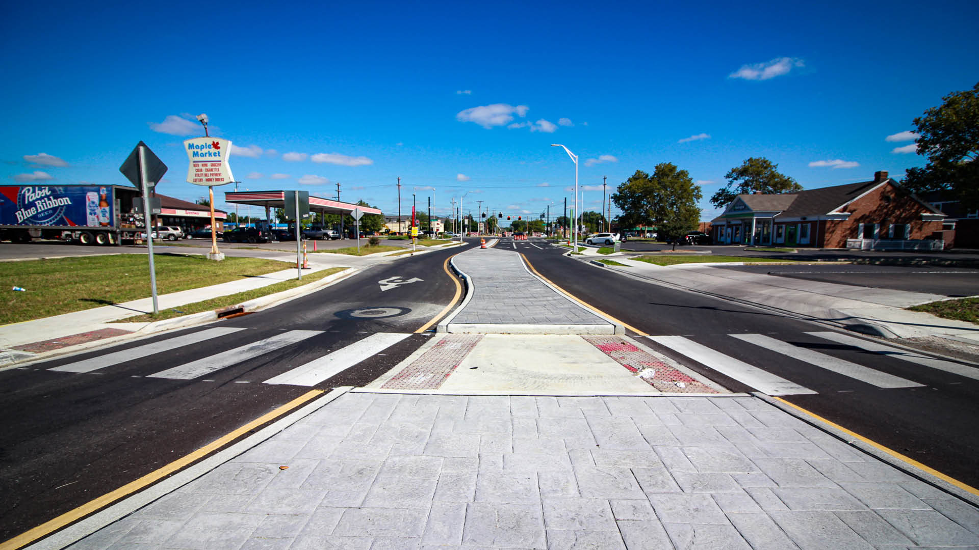
This project also included decorative, gray-stamped concrete, mainline SR 161 signal improvements, a shared-use path, storm sewer improvements, signal improvements, sidewalks, water improvements, street lighting, and BMPs including Silva Cells, oversized pipes, and bioretention swales.
COLUMBUS’ OVERALL VISION
This mini roundabout solution will eventually be constructed at seven sets of intersections along the SR 161 corridor. Construction was completed on Maple Canyon Avenue in September 2023, and this project has improved the corridor’s safety and traffic operations. Construction is underway or completed for three other mini roundabouts within the State Route 161 Corridor Study, and design is ongoing to place roundabouts at the remaining intersections.
As we know, it gets hot and humid in the summer, so let’s take the time and do our due diligence. Please drink fluids as they are important and needed for your body. Heat stress and heat exhaustion are serious, so it is vital that you take precautions to protect yourself.
Water is an essential nutrient for all living things, making up 70 percent of planet Earth and 60 percent of our bodies. It keeps us functioning at optimal performance levels by regulating our core body temperature, carrying essential nutrients to vital organs, and flushing internal toxins. We simply cannot survive without it.
Whether walking to your car or performing a strenuous task at a job site, your body is always working to maintain a balance and sustain its core temperature. And because our bodies are constantly exposed to elements that increase body heat and deplete hydration levels, we must be extra careful when working in extremely hot or cold conditions. Extreme temperatures take a toll on the body, making workers more susceptible to dehydration. Symptoms of dehydration include:
Thirst
Fatigue
Muscle cramps
Nausea, dizziness, or confusion
Excessive perspiration
Hot, dry skin
Dehydration is associated with serious risks, including heat-related illnesses. The HRI spectrum can range from heat stress to heat stroke. So, how much hydration is enough?
As a general guideline, the recommended amount of water intake for the average adult is one quart per hour of active work or exercise. That is the equivalent of 128 ounces every four hours at minimum. It is also suggested that the water intake be distributed over time, such as every 15 minutes per shift.
However, every worker is different. The exact amount of hydration intake depends on the individual. It is important to consider the following factors:
Do any underlying health conditions exist? Individuals and those who suffer from conditions such as high blood pressure, diabetes, and heart disease have different hydration requirements. Taking medications can also alter the body’s tolerance to environmental factors.
What is the level of physical exertion? As the body performs a task, even a basic one like breathing, it loses hydration.
What type of environment is the work being performed in? HRIs are not exclusive to outdoors, as some may think. Many indoor workers are exposed to extreme heat, leaving them susceptible to dehydration and heat stress.
Is the temperature hot? Is there radiant heat coming from machinery and other power sources? If the answer to either of these is yes, then it is very likely that any workers nearby are managing the heat by sweating – and therefore losing moisture. These individuals will need more fluid replacement.
Is the environment new to the individual? The human body can adapt to its environment, but time and acclimatization are required in hot and cold environments.
It is important to make sure we are:
Getting the fluids we need (drink water, with only 1 or 2 Gatorades/Sqwincher throughout the day)
Taking breaks as needed to stay cool
Watching out for our coworkers
Avoiding pop, coffee, and other drinks with heavy sugar and caffeine
Wearing sunscreen when in sunlight
Hydrating the night before
Watch for symptoms of heat stress, like:
Headaches, dizziness, lightheadedness, or fainting
Weakness in the body
Nausea
What to do if an employee gets overheated:
Move them to a cool, shaded area
Loosen or remove heavy clothing
Provide cool water to drink (not ice cold, as this could do harm to the employee)
Fan and mist the person with water
Call safety and your manager
Please be careful and watch over your coworkers.
“For safety is not a gadget but a state of mind.” – Eleanor Everet
DLZ regularly partners with clients to create master plans for parks and recreation facilities. A great site master plan can help you identify program needs, conduct spatial planning, and receive public input. It also assists in setting realistic budgets and develop long-term phasing when needed. Site master plans and the resulting documentation can be utilized to boost your success in fundraising and grant applications for park improvements. Having a clear vision and mission is critical when approaching public officials and potential donors.
Insight into Site Master Plans
Often there is confusion about what a site master plan entails. In a nutshell, a site master plan is a high-level plan for overall, often long term, development of a specific site. It usually includes site analysis and identification of Strengths, Weaknesses, Opportunities, and Threats (SWOT). It reflects conceptual needs and desires for the site, including but not limited to types and sizes of buildings, site amenities such as sports fields, picnic areas, and playgrounds, and natural areas to be protected. A site master plan also takes into account the pedestrian and vehicular circulation, and appropriate orientations and adjacencies between all the onsite elements. It provides a structured approach, clear framework and planning level cost for developing the site.
A site master plan is NOT planning of more than one site or addressing parks’ system planning (5-Year Parks Master Plan) nor is it detailed development of a site plan suitable for construction and/or bidding (Design Development/Construction Documents).
Stages of Site Master Planning
Our process typically includes 4 general stages: Project Kickoff, Inventory and Programming, Preliminary Master Plan and Final Master Plan. The inventory and analysis allows us to identify major constraints or conflicts upfront and gain a thorough understanding of project site. Through programming discussions with our clients and during public input sessions, we gain consensus on needed improvements, help to prioritize ‘wants’ vs. ‘needs’, brainstorm and vet many different ideas, and identify potential partnerships and funding sources early. We take this information gained and use it as the basis for the design of the site master plan. The resulting master plan identifies all proposed improvements and critical adjacencies.
Typically we will have at least 2 master plan concepts for our clients to review at the Preliminary stage. After reviewing with clients and stakeholders or hosting a public meeting, we narrow down the concept to create a Final Master Plan. This plan then helps you communicate a professional plan of action and demonstrate consensus of community. It codifies a long-term vision for a park which leaves no room for no willy-nilly improvements creating obstacles.
Funding and Grants
It provides a realistic basis for immediate funding allocations or long-term budgetary planning for both construction costs and ‘soft costs’ (i.e. professional services, survey, geotechnical investigations, etc.) It can identify project partners and potential funding sources such as Land and Water Conservation Fund grants. This can then be used as supporting documentation for grant applications such as narratives and probable cost opinions.
Graphics can play an important part in communicating your master plan vision. We frequently utilize color-rendered site plans and 3-D renderings. We love that these graphics can serve so many purposes for our clients, from grant documentation to use on social media to create buzz about your projects, park system, and future programming.
At DLZ, we love to see the communities in which we live and work grow in a positive direction. Site master planning is just one way we can help achieve that shared vision. It is our goal that our designs reflect the needs and character of their communities. The best reward is knowing we have helped create spaces for residents and visitors alike to enjoy!
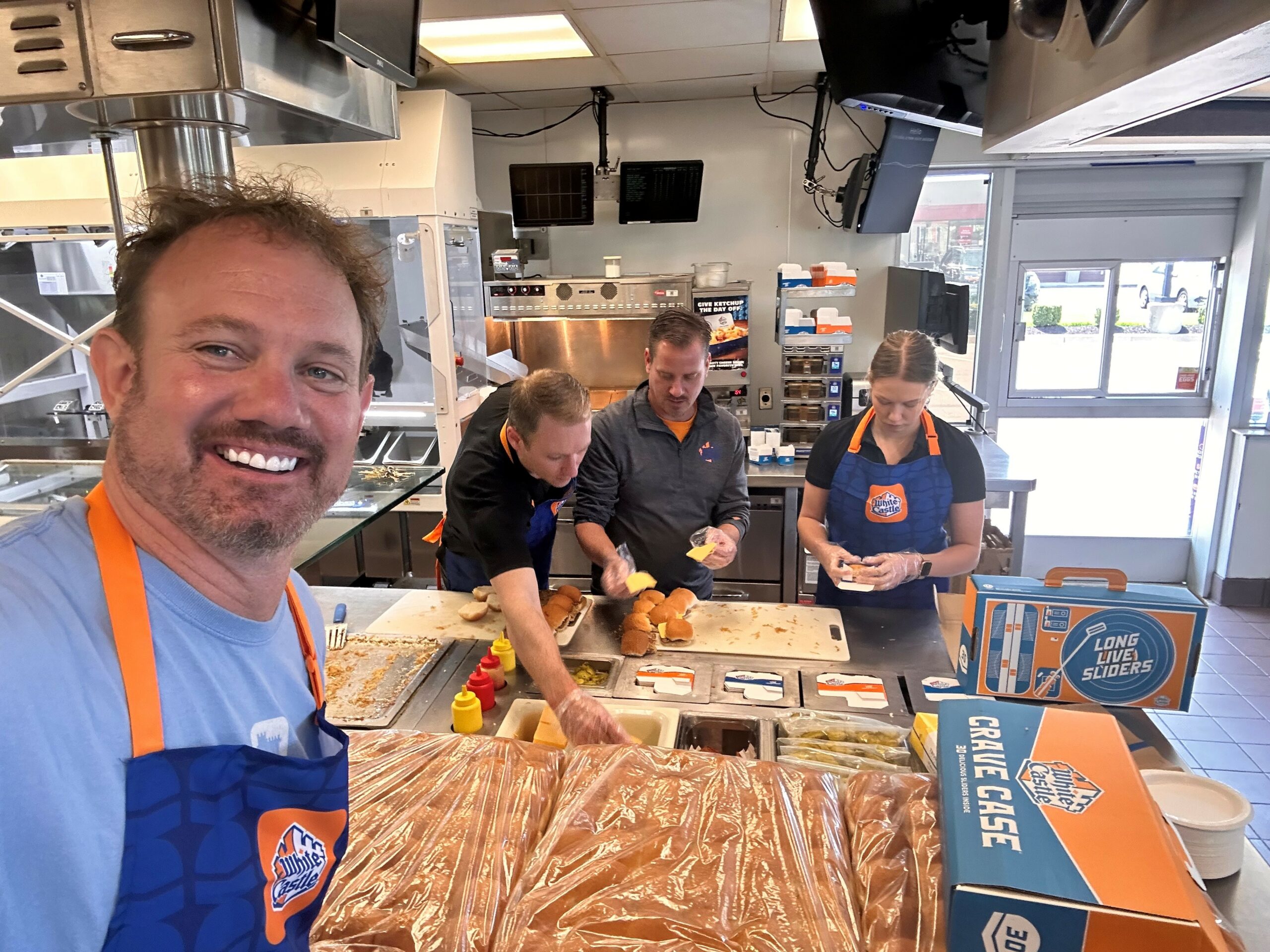
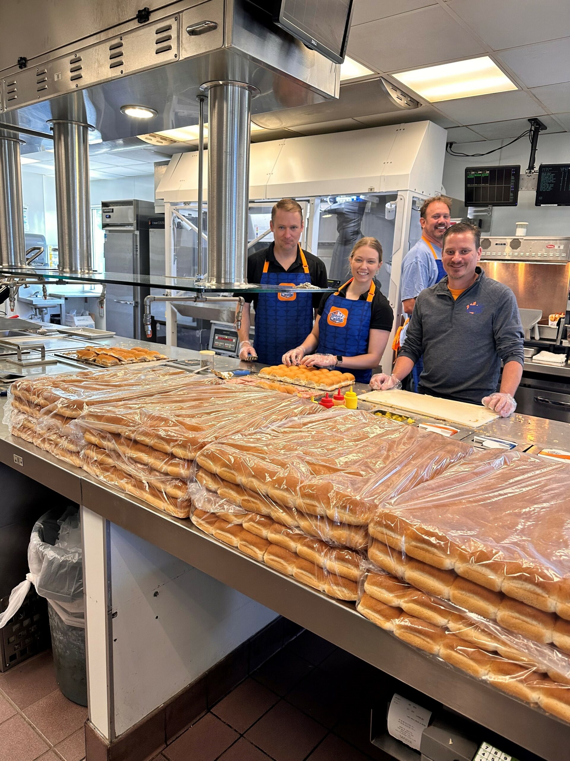
White Castle, the first fast-food hamburger chain in the U.S., helped make the hamburger an American classic when it created The Original Slider in 1921. The popular restaurant is paying tribute to its iconic slider throughout the month of May for National Hamburger Month. The White Castle Restaurant Division invited Home Office employees and their design consultants to brush up on their griddle skills and to give those employees that didn’t start in a Castle the opportunity to see day to day activity.
This year, DLZ employees shared in the celebration of National Hamburger Month! They joined in to work a shift at the White Castle Restaurant in Hilliard, OH. Todd Harkins, Karen Juricic, and Andy Huber worked the lunch shift with the restaurant staff and corporate employees on May 17th. It was an experience I don’t think they will forget. “I have worked with White Castle for many years. So, it was great to finally work a shift at one of the Castle restaurants” said Todd Harkins.
Left to right – Andy Huber, Karen Juricic, and Todd Harkins from DLZ and Travis Evans from White Castle Management Co.
Introducing Flippy and Julia
They also had the chance to work with their two new employees: “Flippy,” the robot who handles the frying process from start to finish, meticulously dropping items into the fryer, removing them at the optimal moment, giving them a gentle shake, and placing them in the packaging area for the team members. Additionally, they welcomed “Julia,” their AI robot, which served as an interactive voice assistant at the drive-thru, adeptly navigating menus and facilitating payments through personal devices. This innovative addition minimized interactions, resulting in a seamless and self-guided experience, encompassing everything from discovery to fulfillment.
“It was a fantastic learning experience,” exclaimed Andy Huber, reflecting on his time. “As an architect, getting the opportunity to witness both the functionality of a kitchen and the inner workings of the equipment was invaluable. It truly aids in designing a kitchen after witnessing everything in action. Moreover, it was an enjoyable and exciting experience to cook food and serve customers for a few hours. However, the ultimate highlight was when we walked into the office with a case of 30 sliders. That got everyone on the team really excited!”
In 2023, DLZ will continue working with White Castle Inc. in their restaurant improvements to the site and buildings.
As we move into 2023 and the construction season is about to ramp up, we need to refresh our minds with Roadway Safety.
Working on or near roadways and highways can be dangerous. We have live traffic, construction traffic, crews, weather, and other hazards. Protecting ourselves and knowing what the hazards are can be tricky, but it doesn’t have to be. Together, we can make sure everyone goes home safe.
As part of field work, we perform many different tasks on roadways which may include:
We need to take a minute, and look over our work site. Ask yourself some questions what is going on today, what crews are in the area, what are the hazards today. With these questions it will get you in the safety state of mind.
The following methods can be used to minimize and control risks for optimum roadway safety:
Be aware of your surroundings:
Working near traffic for extended periods of time can cause you to become complacent to the danger around you from moving traffic
Continually remind yourself and your fellow workers of the dangers to which we are exposed
Remember the common phrase “If you cannot see the driver the driver cannot see you”
Stay out of heavy construction traffic areas where trucks and equipment are moving
Look when you hear a backup horn
Take a look around, use the 20-20-20 rule. Every 20-min. look 20 ft. around you for 20 sec
Remain Alert:
Do not allow yourself or a fellow worker to become distracted
If you need to walk near traffic always have the oncoming traffic facing you, do not walk with your back to the traffic
Do not attempt to talk on the phone when you are working near or around traffic, remove yourself to a safe place away from all traffic if you need to talk on the phone
Know where to cross and park. Routes should be identified and marked to allow workers and work vehicles to safely enter and exit the work space
Move in a predictable manner
Don’t take unnecessary risks
Be visible:
All workers should wear high visibility, reflective apparel, in accordance with minimum roadway safety standards. (Class 3 vest on all roadway work)
Worker visibility during dawn or dusk conditions may be enhanced using fluorescent colored high visibility apparel
If possible, try to exit your vehicle on the curb side rather than traffic side
Notify your supervisor of safety concerns
Make eye contact with operators or truck drivers
Get the operators approval before crossing or approaching trucks or equipment
Park in an area where you are not in a pinch point
In summation, when we are on our job site, continue to keep a look out for traffic, construction crews, and new hazards. Take your time and be alert at all times. Remember the 20-20-20 rule. As always, if we see something say something to ensure roadway safety. We all have the power to use our Stop Work right. Look out for each other and keep our safety minds working.
Remember as we make our way around traveling back and forth to the office, slowdown in the constructions zones, and always drive safe.
“With the new day comes new strength and new thoughts.” – Eleanor Roosevelt
This fall, DLZ sponsored and participated in a Geotechnical Conference on slope stability and mountain road slides in San José, Costa Rica. DLZ Vice President of Water Resources and Dam Safety, Mark Kessinger, and three Geotechnical Engineers from our Costa Rica office – Adrian Ulloa, Monica Vega, and Maria Paula Urena attended the conference.
The seminar, hosted by the Costa Rican Association of Geotechnical Engineers (ACG), carries out geotechnical activities in Costa Rica and is a benchmark institution in the Central American Region. These seminars are held in San José every four years with geotechnical experts from all over the world, including Spain, Italy, Brazil, Columbia, Cuba, Venezuela, and Mexico.
Four Critical Slope Stabilization Areas
During the conference, industry experts highlighted four critical areas related to slope stabilization and the repair of slides along mountain roads.
Geotechnical Experiences Conference speakers shared valuable geotechnical experiences and techniques on many projects all over the world. This knowledge is always productive for all engineering teams because it opens the mind to new ideas that could be applied to future projects.
Technological Advances New technological advances related to geotechnical instrumentation to monitor slopes and excavations beneath existing structures drew strong attention because they demonstrate that new research has led to new technologies recently appearing in the geotechnical engineering field.
Climate Change A third prominent area of interest was climate change and its impacts, associated risks, and threats to slope stability. In general, examples of methodologies to analyze possible landslides were presented using meteorological stations to predict behavior along mountain roads and slopes.
Environmental Model And fourthly, Costa Rica is known to be a model environmental country. In October of last year, it was one of only five countries to receive the prestigious Earthshot Prize for its contributions to environmentalism in the Protect and Restore Nature Category. So, one of the conference’s main topics was related to a mountain road with numerous landslides. The road is in a protected area of the Braulio Carrillo National Park. Several presentations were given on the sustainable repair of 80 miles of this critical mountain road by 2027 at nearly $70 million dollars.
Leaders in our Industry
DLZ representatives gave two presentations during the conference.
Mark Kessinger described successful stabilization methods for slopes in the Appalachian Mountains. The audience received this topic very well because the projects were outside Latin America, where most of the projects presented were located.
Monica Vega gave a presentation on DLZ’s engineering and design efforts to protect the upper guide wall at the U.S. Army Corps of Engineers’ Dashields Locks and Dam on the Ohio River near Pittsburgh, Pennsylvania. She explained how DLZ is working to stabilize the slope failure that is moving toward the wall and threatening its collapse, which would lead to the closure of this vital lock chamber.
This conference was an excellent opportunity for DLZ to share its work, promote its services, learn about new methods, share our experiences, and connect with geologists and geotechnical engineers from around the world.
High-definition laser scanning (HDS) has risen over the past few decades to be one of the most versatile surveying technologies available to the market. By completing a complex array of HDS projects within the heavy industry, DLZ has been proven to provide accurate and timely deliverables. This article showcases only a handful of the newest processes that DLZ is employing to provide accurate and timely deliverables while saving our clients’ money.
DLZ’s Evolution of Processing and Analysis:
Utilizing Automation
One of the major bottlenecks of working with HDS data as scan technology has evolved to greater levels of accuracy as well as gathering colored scan imagery is file size. Small HDS projects can generate dozens of gigabytes of data all the way up to large projects generating terabytes worth, straining IT infrastructure, and commanding increased time to process. While a variety of commercially available software is available to 3D models within point clouds, very few softwares offer automated extraction. With the lack of effective commercial software for point cloud analysis, DLZ has set itself apart from other engineering firms as early as 2017 by implementing customized programming to automate the most time-consuming data extraction from point clouds. This customized programming operates across multiple coding languages and software packages but has met limitations. While there is no singular data analysis software available, new software and better workflow procedures have opened new means for point cloud analysis.
DLZ’s Implementation of New Methods of Analysis
Every project comes with a unique set of challenges and needs for each client. Once the client’s needs have been identified with face-to-face on-site visits, the method and trajectory of the project are determined to meet the client’s desired goals. The variety of analysis needed can be displayed in three projects that required significantly different approaches to their analysis with unique output goals for each.
Petroleum Tank Strapping Tables – Meshed Volume
A local large-scale refinery requested DLZ to laser scan the interior of a newly finished tank and to generate strapping tables (tabularized volume by vertical increments) for this new vessel to be put into service. Existing manual methods were in place for performing this task requiring approximately 80 to 100 person-hours to complete. Using modern 3D meshing and automated data extraction, the turn-around time for the deliverable was reduced by over 80% while retaining accuracy.
Wastewater Processing Tank – Cloud-to-Best Fit model
An industrial facility processing wastewater from steel coil processing was concerned about the integrity of the aging wastewater tanks used to separate the contaminants from lake water. The interior of the vessels was scanned once the base concrete surface had been cleaned. The scan data was used to generate a best-fit model of the conical-shaped bottom to compare the condition of the concrete. Existing automation would have required 4 man-hours to write code and generate the output data. The latest automated methods completed the same task in under 1 hour, completing millions of comparisons between the point cloud and the best-fit model. This output was used to create a colorized deviation map of the cone.
Wastewater Treatment Basin – Cloud-to-Mesh
A local steel mill wanted to track the erosion on a concrete equalizing basin over concerns of excessive wear leading to leaks. The basin was scanned twice, one year between the visits, allowing the concrete to be cleaned before each visit. Current automation methods would only be able to compare deviation from best-fit surfaces, which will not account for small fluctuations in the surface. Using next-generation software and analysis methods, a mesh was generated from the point cloud data of the first visit. The point cloud of the later visit was then measured relative to this mesh, allowing comparison of the same position 1 year apart delivered to the client in colorized deviation. Analysis of this type was impossible up to this point.
Basic Oxygen Furnace (BOF) Cooling Tower – Cloud-to-CAD Model
A steel producer needed consultation on their decision as to whether or not to replace the worn BOF cooling tower at their facility. The client’s end goal was to determine the amount of distortion the structure had suffered over its service. To determine this distortion, a 3D CAD model was supplied to establish the design condition of the tower. Traditional automation required days’ worth of cleaning the point cloud due to the exceptionally crowded working space around the tower and code generation. Updated methods now allow for the client-supplied CAD model to be inserted into the point cloud and will automatically clean the cloud, only leaving the data collected on the tower itself. This cleaned data is then measured relative to the CAD model to generate a colorized deviation map for the client. This entire workflow takes hours compared to days for the old process.
DLZ on the Leading Edge:
The advancement and evolution of HDS technology require an equal evolution of post-processing capabilities. This evolution means that processes that used to take days now only take hours and allow for higher accuracy and deliverables that were not previously possible. DLZ remains on the leading edge of HDS technology adoption and adaptation of newer, more efficient methods of analyzing point cloud data. This results in data DLZ’s clients can rely on while maintaining time and budget requirements.
Over the last two articles, I introduced you to the Ohio River Basin Alliance (ORBA) and presented ORBA’s strategies to make sure we continue to have abundant clean water. In this article, I’m going to discuss ORBA’s plans to maintain the basin’s healthy and productive ecosystems.
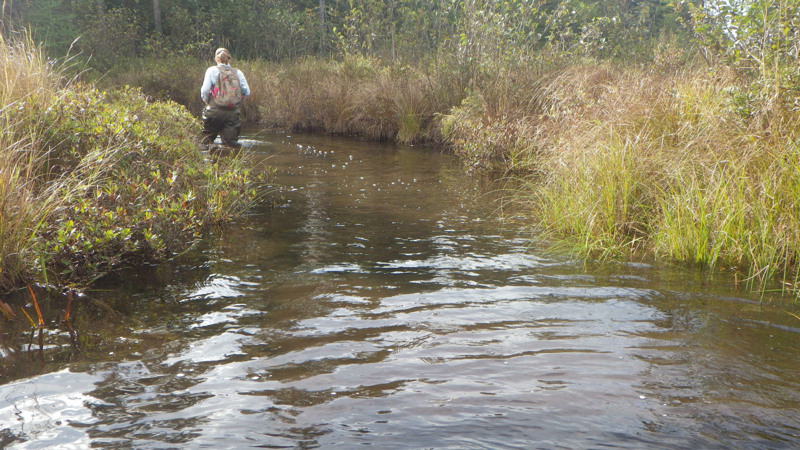
DLZ employee conducts water quality testing along the Portage Creek, as part of a study to improve the area’s ecosystem
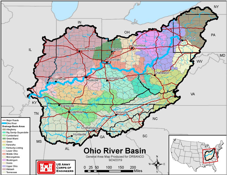
First, let’s talk about how diverse our ecosystems are in the Ohio River Basin. Did you know the Ohio River and its tributaries are home to 164 species of fish and over 100 species of mussels? The Ohio River Basin is very large and covers an area of 200,000 square miles with about 7,000 miles of waterfront along the Ohio River and its main tributaries. The Basin is nationally and internationally renowned for its diversity of ecoregions that distinguishes it from other basins within the United States. As shown on the map below, portions of 16 different ecoregions are found within the Basin making it one of the most diverse and productive regions in the nation. In fact, the Green, Tennessee, and Cumberland River sub-basins are among the richest ecological regions in the world based on species diversity.
Source: U.S. Army Corps of Engineers
Although rich in diversity, human activity has led to the loss of wildlife habitat that negatively impacts native wildlife populations. Of the 127 mussel species once found in the Ohio River, 11 are now extinct and 46 others are threatened, endangered or a species of concern.
Also, unfortunately, non-native invasive species are moving into the basin every year and threatening our native species. Invasive species already present in the basin include Asian carp, zebra mussels, emerald ash borer, and kudzu. These invasive species are capable of outcompeting native species for resources, altering ecosystem functions, and causing disease, and remarkably their impacts cost billions of dollars to the nation’s economy each year. Typically, invasive species often grow faster, disperse over larger areas, and have few natural predators so they can outcompete native species, reduce biodiversity, degrade water quality, and negatively affect our recreational, commercial, and agricultural activities.
The condition of our soil also has a profound impact on our ecosystems as well as water quality. Presently, our soils along with their nutrients are being eroded from farmlands at a greater rate than it can be replenished. Improving the health of our basin’s soil for water infiltration is an effective way to decrease runoff and improve moisture content and nutrient retention for healthy crops.
One of my last projects with the U.S. Army Corps of Engineers was a pilot study that evaluated the impacts of climate change on the Ohio River Basin. According to the climate change models conducted during the study by the National Weather Service, the average temperature is expected to rise a half-degree per decade from 2011-2040 and a full degree from 2041 to 2099. This rise in temperature causes changes in precipitation, which of course, impacts flows. The changing patterns in our precipitation will create more challenges for not only maintaining our ecosystems but also for agriculture, industries, and communities that need reliable water sources.
So How Do We Maintain Healthy and Productive Ecosystems?
As part of the strategic plan for the Ohio River Basin, there are three main objectives for maintaining and enhancing our ecosystems.
Objective 1: By 2022, basin states, conservation organizations, the USEPA, ORSANCO, and other stakeholders will work together to develop a plan to improve the basin’s ecosystem through the identification of at-risk ecosystems and the threats to them such as acid mine drainage and emerging toxic contamination. Strategic actions that ORBA stakeholders plan to take to meet this objective would be to facilitate coordination among The Nature Conservancy, the US Fish and Wildlife Service, the National Wildlife Federation, the Ohio River Basin Fish Habitat Partnership, the Southeast Aquatic Resources Partnership, and other stakeholders to develop and restore the basin’s aquatic ecosystem.
Objective 2: By 2025, secure funding to initiate a federal geographic program to restore the basin that meets the needs of the states, the USEPA, ORSANCO, and other stakeholders. Basin stakeholders would establish an Ohio River Basin Restoration Initiative using guidance from similar restoration initiatives such as the Chesapeake Bay Restoration Program, the Columbia River Restoration Program, and the Great Lakes Restoration Initiative. They would also work to restore floodplains and protect existing high-quality habitats and native aquatic populations. In addition, they would expand upon the Natural Resource Conservation Service’s existing Mississippi River Basin Healthy Watersheds Initiative to pursue a healthy soil initiative to protect farmlands and improve erosion control, water retention, and fish and wildlife habitat.
Objective 3: Implement strategies to eradicate, control, and manage invasive species utilizing sound scientific data and effective control methods. Also develop and implement education and outreach programs to increase the understanding of the negative impacts of invasive species. ORBA will advocate for existing organizations like the Aquatic Nuisance Species Task Force to develop and implement a basin-specific program to study, monitor, and control invasive species. It will also advocate for basin funding in 2021 for the Asian Carp National Plan.
Next time we’ll look at the 3rd goal – performing research and improving education so the public and decision-makers can make informed decisions. If you’d like to join ORBA, contact Dr. Harry Stone at hstone@orsanco.org.
In the first Ohio River Basin blog series, I shared an overview of the Ohio River Basin Alliance (ORBA). ORBA is a volunteer group of more than 130 organizations that are working together to sustain healthy ecosystems along the Ohio River and its tributaries and to improve our water-dependent economies.
Since the first Ohio River Basin Summit in 2009, in Covington, Kentucky, there have been 11 summits in 5 states where ORBA members worked to develop goals for the Basin to ensure the quality and quantity of our water will support our environment and local economy. Recently, the U.S. Army Corps of Engineers Louisville District released a study entitled, “Plan for the Ohio River Basin 2020 – 2025”. The purpose of the study was to create a basin-wide strategy that identifies goals, objectives, and actions for improving the ecological well-being, economic health, and quality of life for residents throughout the basin.
In this blog, I will focus on the first goal – ensuring we have abundant clean water.
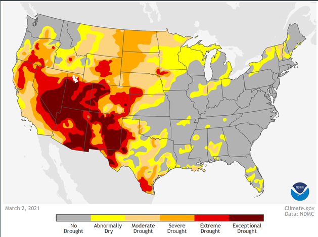
Fortunately, we who live in the Ohio River Basin live in a water-rich region. Talk to residents in the southwestern states and you’ll understand what an environmental, and economic asset that is. NOAA’s recent drought projection shows extreme and exceptional drought projections for most of the southwest for the coming year.
The categories shown along the bottom of the map reflect how much water is available in streams, lakes, and soils compared to normal amounts for this same time of year. The darker the shade on the map, the more intense the drought conditions. You will notice that the Ohio River Basin is not expected to have drought conditions this year, so we should have enough water to sustain our ecosystems, agricultural industry, and local economies that depend on it. That may not be the case for many of the southwestern states.
Abundant Clean Water
Federal, state, and local agencies have made significant progress in improving water quality in the Basin since the passage of the Clean Water Act in 1972; however, much work still remains to address non-point source pollution, legacy contamination, and contaminants of emerging concern. Water quality and water quantity monitoring are critical in making informed decisions. Expanding the number of gaging stations throughout the Basin will be an important step in managing our water resources in the future. Already realizing this, the USGS has been increasing the number of its gaging stations in the basin over the last ten years.
On the bright side, collectively, ORBA stakeholders have the expertise and experience required to address these water quality and water quantity challenges. The strategic plan lays out a plan for them to work together to accomplish the following five objectives by 2025.
Objective 1: Organizations will work together to increase the number of water bodies in the Basin that meet the Clean Water Act’s standard in 2030 compared to 2020.
Strategic actions that ORBA stakeholders would like to take to meet this objective would be to develop a comprehensive GIS database to support Clean Water Act initiatives and inventory acid mine sites, coal ash ponds, and underground mine pools. Once these sites are inventoried, stakeholders would develop a reclamation strategy to clean up ten high-priority sites. Other steps would be to support agencies’ efforts to implement Clean Water Act requirements through improved water quality standards as well as supporting agencies’ efforts to monitor and assess health risks due to contaminants of concern. Another action would be to expand the number of USGS gages to improve water quality and water flow information.
Objective 2: Develop strategies to enhance current source water protection programs to meet the Safe Drinking Water Act requirements and support organizations that currently do not have source water protection programs.
Actions that ORBA can take to meet this objective are developing a GIS platform to map source water protection areas, listing contaminant source inventories and contaminant spill locations, and other water protection risk zones. It can also expand ORSANCO’s Ohio River Organics Detection System to respond to spills that may impact the Ohio River and its tributaries. Furthermore, it can work with ORSANCO to build water protection strategies for all water bodies in the Basin that serve as a drinking or industrial water source.
Objective 3: Identify water bodies in the Basin with high incidences of harmful algal blooms (HABs) and help stakeholders develop responses to reduce the number of occurrences between 2020 and 2030.
To address this objective, ORBA can develop a GIS platform to map waters that have HAB occurrences in an effort to achieve a reduction in HAB events. They can also support monitoring and response strategies of other organizations to maintain safe recreation and drinking water. In addition, ORBA can identify and inventory point and non-point nutrient sources and work to reduce nutrient contributions into the Ohio River Basin waters.
Objective 4: The Ohio River Valley Water Sanitation Commission (ORSANCO) will assemble water quantity managers from across the basin to identify problems affecting water quantity and recommend strategies to address water shortages.
ORBA can develop a GIS platform to map flood risk areas, drought mitigation planning areas, and water supply deficit or surplus areas. Other actions would be to expand the USGS stream gage network to measure flows in the Basin’s streams more accurately and improve hydrologic and hydraulic models to see how our infrastructure will handle expected climate changes.
Objective 5: Inventory drinking and wastewater system infrastructure needs across the Basin and develop a strategy to maintain these systems.
For this objective, ORBA could develop a GIS platform to inventory drinking and wastewater infrastructure needs in the Basin and work with the USEPA to address these aging assets.
Of course, to do all this work requires funding, so securing the financial resources to take these actions is paramount. Next week we’ll look at the 2nd goal – how we can enhance the Basin’s ecosystems to support the natural habitats and fish and wildlife that depend on them.
The Ohio River Basin Alliance (ORBA) is a volunteer group of stakeholders who work together to set water resource priorities for the Ohio River Basin to sustain healthy ecosystems and communities and improve our water-dependent economies.
ORBA provides a forum for addressing water resource issues in the Ohio River Basin in today’s changing environment. ORBA includes members from over 130 organizations, including local, state, and federal agencies, commissions, industry, academia, and not-for-profit organizations.
How It All Started
In 2009, in addition to serving as Commander of the U.S. Army Corps of Engineers Great Lakes and Ohio River Division in Cincinnati, Major General John Peabody also served on the Mississippi River Commission. The Commission’s purpose is to improve navigation and prevent destructive floods on the Mississippi River. Knowing the vital role the Ohio River plays for the nation, General Peabody investigated the possibility of forming a similar commission to oversee the Ohio River. He learned there had been an Ohio River Commission prior, but it was abolished during the Reagan Administration to downsize the federal government. General Peabody knew it would be an uphill battle for Congress to re-establish the commission. He thought the next best thing to do would be to assemble representatives from various stakeholders from all backgrounds and interests within the basin to discuss the basin’s needs and set priorities.
That is where I came in.
I worked at the Huntington District Corps of Engineers and served as the Corps’ Liaison to the State of Ohio and the U.S. Department of Energy’s National Energy Technology Laboratory. Because of my experience in building collaborative relationships, I was asked to establish a stakeholders’ group for the Ohio River Basin in Cincinnati. The basin is large, which many people don’t realize. It covers over 204,000 square miles, is home to 25 million people, and includes 15 states stretching from New York to Alabama.
Source: U.S. Army Corps of Engineers
Our first meeting, called “The Ohio River Basin Summit,” was held in 2009 in Covington, Kentucky, across the Ohio River from Cincinnati. Sitting in a conference room overlooking the river, a group of nearly 100 stakeholders agreed to form a volunteer group and work together to set priorities to improve the basin’s environment and economy. This group came to be known as the Ohio River Basin Alliance, or ORBA.
Initially, ORBA was co-led by the Corps of Engineers, the Ohio River Valley Water Sanitation Commission (ORSANCO), and the U.S. Environmental Protection Agency. Some stakeholders were unsure of the purpose of ORBA. Many thought it was a Corps of Engineers’ effort to gain more power over water resources in the basin. But over time, the parties built mutual trust and worked together to complete the first study to create a basin-wide strategy in a report “Plan for the Ohio River Basin 2020-2025.”
ORBA’s Goals
ORBA has established six main goals to ensure the quality and quantity of our water will support the environment and the economy.
Abundant Clean Water: Ensure the quality and quantity of water in the Ohio River Basin is adequate to support the economic, social, and environmental functions that are dependent on it.
Healthy and Productive Ecosystems: Conserve, enhance, and restore ecosystems within the Ohio River Basin to support natural habitats and the fish and wildlife resources that depend upon them.
Knowledge and Education to Inform Decisions: Ensure that research and education adequately inform Ohio River Basin-wide economic, social, and environmental decisions; enhance the profile of education organizations in the Basin that synergize efforts to garner effective public involvement in the stewardship and management of the Basin’s resources.
Nation’s Most Valuable River Transportation and Commerce Corridor: Provide for safe, efficient, and dependable commercial navigation within the Ohio River Basin to ensure a competitive advantage for our goods in global and regional markets; sustain a water use system to efficiently and effectively support agricultural, industrial, and energy productivity.
Reliable Flood Risk Management: Provide reliable flood risk management through well-managed and maintained infrastructure, including appropriate floodplain connections for water conveyance and ecosystem benefits, and management of surface and stormwater runoff to protect life, property, and economies better.
World-class Nature-based Recreation Opportunities: Enrich the quality of life for people and recreation-based economies by maintaining and enhancing riverine, lake, and wetland-associated recreation within the Basin.
Plan for the Ohio River Basin
Recently, the Corps’ Louisville District, in collaboration with ORSANCO and ORBA, released the first basin-wide strategy to create a blueprint of goals, objectives, and actions through 2025 for improvements in economic health, ecological well-being, and quality of life for those of us living in the basin.
In this blog series, I’ll describe ORBA’s strategies and action steps to meet the goals. Next week I’ll present ways we can work together to achieve the first goal of ensuring we continue to have abundant clean water.
Traffic simulation can be applied to roadway design, transportation operations, and roadway construction projects. It demonstrates how well the project works realistically.
Microscopic traffic simulation models simulate traffic systems on a vehicle-by-vehicle basis by updating vehicle position, speed, lane position, and other variables on time steps, like a split second, while the vehicles interact with the roadway geometrics, traffic signals, pedestrians, other vehicles, and any operation situations. Each vehicle model is based on driver behaviors in car-following and lane changing. Traffic simulation models effectively evaluate heavily congested situations, complex geometric configurations, and system-level impacts of proposed transportation improvements.
In the past, we have used simulation software – VISSIM, VisWalk, SimTraffic, and CorSim, to name a few – in projects such as:
I-390 & I-290 Interchange
Highway design and interchange designs
This includes all types of interchanges. Take I-290 and I-390 interchange design projects as an example to illustrate how the simulation model is a helper. The interchange has a few close-spaced interchanges before and after this interchange. The design team had a preliminary design. They then developed VISSIM models to simulate the designed geometry and the forecast traffic for the design year. The simulation model visually shows the long queues on some of the on-ramps. With this result, the design team created a new iteration. The new design, modeled in VISSIM, showed smoother traffic. Another issue the VISSIM model discovered with the original design was the acceleration lane length at WB I-390 to SB I-290 ramp. The new design resolved this issue as well. Putting the design into a simulation is like “seeing” the future. The models help foresee any potential problems before it’s too late.
Transportation operation simulation
Simulation models can help to evaluate the effectiveness of any transportation operation plan. For example, Active Traffic Management, including ramp metering, dynamic speed limits, etc. The example project we did was the signal control at a roundabout. We developed a VISSIM model to simulate the red/green/black signal at one leg of the roundabout to control the flow entering the roundabout, leaving enough space for the traffic to enter from the upstream leg. The simulation model came up with the recommended optimal timings.
Work zone mobility analysis
For construction projects covering a larger area, the simulation models are best in estimating the additional user travel times due to construction conditions and detours. For example, we developed Synchro/SimTraffic simulation models for US-127 and US-127 BR construction projects. The model covered 5 miles of US-127 and 6 miles of US-127 BR and the intersection/interchanges along with them. The travel routes’ comparisons were made using the simulation models, and the user costs were calculated for detour and base conditions.
Multimodal transportation system
When the transportation system includes public transportation, private auto, trucks, pedestrians, and bicycles, it becomes complicated, especially the different modes’ interactions. Simulation models can simulate all different modes and their interactions to show the results of the mixed traffic. For example, the Mackinac Island transportation modes include ferries, horse-drawn carriages, bicycles, and pedestrians. VISSIM/VisWalk models were developed to simulate all these different modes and traffic, including passengers coming out of the ferries onto the street, bicycles coming out of the bike rental and entering the street, and horse-drawn carriages traveling on the street and pulling into the ferry dock waiting area. The models were used to evaluate the ferry departing and arriving on different docks and the impact on the streets.
In conclusion, simulation models have a wide range of applications. Used properly, it helps better evaluate the designed transportation system and create convincing findings.
GIS (Geographic Information Systems) has been around for some time now, and most communities use it every day for various procedures. If you’re new to GIS, it is a computer system cable of capturing, storing, analyzing, manipulating, and updating spatial data as vector data (Points, Line and Polygons). It’s often used to identify relationships between vector data, scheduling upkeep to certain vector data, and making future for expansion, just to name a few. DLZ also uses GIS to enhance plans, proposals, surveying, and other practices.
DLZ has a wide-open field for assisting local communities with “Maintenance of Assets”. So, what am I talking about? “Maintenance of Assets” can be many different things. In this instance, we’ll focus on Inventorying of Community Data. Most local communities, either by State mandate or local Governments, must inventory and keep up to date information on assets such as signs, signals, etc.
These municipalities must project useful life for all roads, bridges, signage, signals, safety features, and other assets under their jurisdiction and report assets and asset depreciation.
The communities often use this inventory to determine if an asset needs replaced (e.g., sign or signal needs replacing). DLZ has the people and infrastructure to gather data, create a database, and map the data for potential community clients to assist these communities.Scheduling a kickoff meeting with the client very early is a good idea. Together, outline a detailed proposal. To get a better understanding, we may ask the following:
What data should be gathered (e.g., signs, road quality, etc.)?
What is the boundary area of the data to be acquired?
Are photos required?
What additional data is necessary for the database?
What coordinate system and delivery format is desired?
These are just a few questions, but aids in determining the first stage of the data gathering. Also, you may want to start gathering data within a “Sample Site” location.
Visually presenting a GIS map with a client’s “Sample Site” data can show them what data they will get, how the database information is presented, and help them update anything at the data-gathering stage. Additional database information such as extra columns for further details within the database, scans of surveyed manholes and photo hyperlinks for visual information are just a few items that a client may want to have for future use.
Likewise, during the first stage of data gathering, you may want to determine with the client if there is to be a numbering system setup for any points (e.g., Manholes, Signs, etc.) and if a grid system for aiding in quickly locating the point is necessary. A numbering system will assist with present and future item identification. If a numbering system is initially structured when gathering field data, the field personnel can set an automated numbering system in the database. This can then be renumbered or enhanced with additional characters within the database during processing.
Once a GIS map with the database is created, reviewed both “in house” and by the client and accepted by the client, DLZ can deliver the data to them in the format of their choice.
But the new working relationship doesn’t end there! The client may have additional questions on how to use the database and keep it up.
Furthermore, they may also want help with a new project. You never know when a potential GIS opportunity will come around.
“Beyond the Zoom: A Passion to Support Nationwide Children’s Hospital”
I recently had the opportunity to interview Gary Bowen for DLZ’s Executive Spotlight, a blog showcasing DLZ leadership to get to know team members personally and discover a hidden talent. While Gary is an accomplished Vice President with more than 22 years of experience, he also dedicates himself to children’s causes. A particularly urgent cause around the holiday season is that many organizations depend on the generous spirit of volunteers.
We talked about his passion for philanthropy, and how his volunteer work complements his professional life. We started off by discussing his early years. Gary reminisced, “I’ve been part of the DLZ family for 22 years, and it was my first “real job.” I was a recent college graduate who painted houses until I could find an opportunity to start a career. One of my first interviews was with DLZ, and Barry Wong made me an offer on the spot. I accepted the position, not really knowing what to expect. Barry took me under his wing and provided the kind of mentorship that is part of why DLZ is so successful. Like so many people at DLZ, Barry took the time to develop the people on his team and ultimately makes everyone more successful. In a lot of ways, I have grown up at DLZ, starting in the field and the lab as a technician and then progressing through several positions within our Field Services discipline. I have loved every minute of it and always enjoy the challenges of the job.
One of my favorite aspects of my time at DLZ has been working on hundreds of projects that have made a real difference in the community. I’ve enjoyed getting to know our clients and building teams that can solve their problems no matter how complex. I hope I have been able to pay it forward by mentoring others along the way.
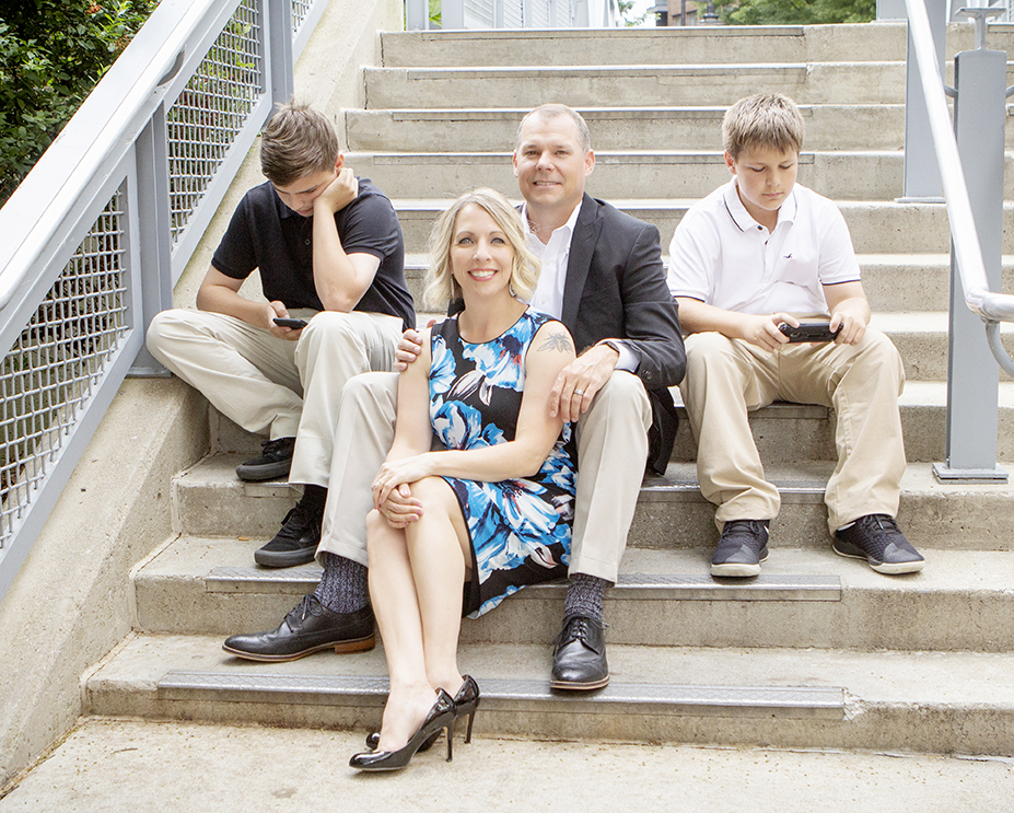
I was born in Maryland, grew up in Central Kentucky, and have lived in Columbus, Ohio, for over 20 years.
I’ve always loved the outdoors, whether it is boating on the Chesapeake Bay or hiking in the Red River Gorge, and I think this made it easy to be passionate about construction and sustainability. I met my wife, Maura, while attending Centre College in Danville, KY, and I moved to Columbus after graduation to start our life together in her hometown. Maura works for the Abbott Nutrition Health Institute and is a great writer, successful podcaster, and loves music.
We have two sons: Henry, who is 15, and Ollie, who is 13. Henry is a great drummer, has started investing, and loves to cook. Ollie loves football, baseball, basketball and is always up on the news and current events. I’ve been fortunate to coach their teams and volunteer for a lot of their other activities. As a family, we love to travel. We’ve been to Ireland, Canada, Mexico, France, Italy, and Spain and hope to make a trip to Japan. We also love hiking, camping, fishing, and boating.
Gary Bowen’s Family (L to R): Henry, Maura, Gary, Ollie
I’ve always had an interest in philanthropy and have sought out opportunities to donate my time and energy to causes in the community. While at Centre College, I found several opportunities to give back, including being the philanthropy chair for my fraternity, coordinating campus blood drives, volunteering at the local hospital, and organizing Fall yard cleanups for elderly community members. Fast forward to moving to Columbus, joining DLZ, and marrying my college sweetheart, both our boys dealt with severe respiratory issues as infants. They received world-class care at Nationwide Children’s Hospital (NCH). Maura and I were so grateful for the care our boys received. We were so impressed with the hospital staff and capabilities but experienced firsthand the fear, uncertainty, and heartache of watching our asthmatic children unable to breathe. We had the experience of having one of our sons tested for cystic fibrosis and remembered the anxiety of waiting for the results, knowing that the news is not good for families in many cases. We were fortunate to receive good news and ultimately have two healthy children but realized not everyone is that fortunate, and we’ve seen how critical NCH is to the community.
Our experiences with NCH motivated me to find a way to give back. In 2009, I discovered the Development Board, which is a dynamic group of philanthropic-minded business professionals who give generously of their time, talent, and resources to further the life-saving mission of Nationwide Children’s Hospital. Founded in 1971 to enhance the relationship between Nationwide Children’s and the local business community, the Board has grown to more than 175 active and life members representing a wide variety of companies and industries throughout central Ohio.
The funds the Development Board has raised over the years have benefited annual needs as well as long term and critical needs identified by the hospital. The Development Board has been instrumental in funding:
$1.0 million endowment fund for the hospital with the goal of reaching $1 million by 2000 (1997)
$1.5 million Endowed Chair in Critical Care Medicine (2008)
$2.5 million gift agreement benefiting the Research Institute at Nationwide Children’s Hospital and the Center for Family Safety and Healing. (2018)
$200,000 gift to the Lawyers for Kids program at Nationwide Children’s Hospital (2020)
In an effort to raise money throughout the community, the Development Board hosts several city-wide events. These include the Woody Hayes Celebrity Classic, Pay It Forward Party, Rock ‘N Bowl, Columbus Duck Race and Slice of Columbus. These fundraisers have raised more than $18 million since the creation of the board to support the good work of Nationwide Children’s Hospital.
Since 2009, I had the honor of serving on several event committees, founding/chairing the Columbus Duck Race, and serving as the Secretary, Treasurer, Vice President, and the President of the Board. It was an honor to lead an organization that makes such a significant impact on the community and the world through fundraising for treatment and research. I’ve always encouraged DLZ staff to get involved in the community and find something they are passionate about. The relationships you develop volunteering are meaningful in the business world, and you get opportunities to develop skills that may also be beneficial in your career. I found opportunities to lead diverse groups of volunteers, plan large scale fundraisers, manage event logistics, develop corporate fundraising strategies; all while developing my leadership style, and making lifelong friends.
I also gained a better understanding of the role Nationwide Children’s plays in our community.
The patient care portion was evident to me the first time I walked into the hospital. I quickly learned through the Development Board that the hospital also provides advocacy for children and families, pediatric research, education, and behavioral health services. While all of this is important, pediatric research became a focus for the board and me as an individual. The ability to improve children’s outcomes locally and globally through research will always be something I am passionate about and I hope others will be too.
As we finished our time together, Gary was headed off to meet with his team on a current project. To learn more about the Development Board or if you would like to donate, click here.
2020 will long be remembered for a variety of things, most of which we would just as soon forget! The coronavirus pandemic has resulted in changes to our normal way of life, both personally and professionally. The shutdown of many facilities early in the pandemic, both public and private, altered the way we shopped, worked, and interacted with friends and family. The essential workers in the private and public sector, some with health conditions of their own or with family members at home with health conditions, were not able to pivot to some of the changes others could. They had to go to work to serve others and we appreciate them all. Similarly, the operations of most governmental entities had to continue, with several local governments scrambling to figure out how to continue their operations safely and in compliance with open meeting laws that vary by state. Most used technology to hold online virtual meetings, which have a unique set of accessibility requirements to ensure persons with disabilities can participate in online meetings. In the midst of the pandemic, DLZ sponsored a webinar on ways to provide accessible online meetings. You can watch it here.
The 2020 General Election was also a notable event. All the rhetoric and reporting on various voting issues – from mail-in ballots to voter suppression allegations – have been all over the media. Yet very little attention was focused on ensuring voting access for the disabled. Nearly 20% of the U.S. population has one or more disabilities, many of which could impact their ability to access polling places that have engineering or architectural barriers. Most states have polling place checklists for accessibility to ensure that facilities that sponsor these one day events meet the minimum access needs for the disabled.
Simple issues that most of us take for granted, such as convenient parking, good sidewalks, and doors that are easy to open, can be a significant barrier to the disabled to even get into a facility that is being used for voting. There are stories following elections about disabled people that were denied their right to vote because they were not able to access the building for reasons that can easily be fixed, though at a cost. Election officials should understand the importance of their selection of polling locations, which are often churches, schools, and other non-municipal buildings, but also ensuring the accessibility of those facilities. This needs to be done well before an election so that accommodations or physical changes can be made to ensure accessibility for disabled voters. Expansion of absentee balloting is an excellent accommodation, but voters that want to personally visit the polling place and cast their ballot cannot be denied. It’s their right as an American.
Today, 30 years after the adoption of the Americans with Disabilities Act, many government entities have facilities that have various accessibility issues. These physical facility barriers can be identified through an ADA self-evaluation, which DLZ can assist you with by providing experienced professionals to perform inspections or train your staff on how to complete them. Government programs and the policies and procedures in place to implement them is an accessibility need often overlooked. Only through an evaluation of these potential non-physical barriers can a comprehensive ADA Transition Plan be developed to map out a strategy to ensure accessibility to all government programs.
As we see much more emphasis on the technology side of accessibility needs, including websites and access to the virtual meetings, I would anticipate this topic to be more prominent this year. As we settle into 2021, there will likely be new Federal guidance provided for access to technology for the disabled, especially websites, given the increase in use of the internet for so many of our normal day-to-day activities.
We urge all public and private entities out there to consider the accessibility needs of their customers before it becomes an issue and results in complaints, whether formal or not, or loss of business. Like most things, fixing something before it becomes an issue is typically much less costly than after it becomes a problem. We’re here when you need us. We can help you understand your accessibility obligations.
DLZ’s landscape architects carefully select plant species on each of our projects to meet clients’ specific needs, and these selections frequently include native plants. Let’s talk about four great reasons for utilizing native plants on your next project.
#1 – Lower Maintenance and Increased Sustainability.
The number one request we hear from clients is for low maintenance landscapes. One of the best ways we can accommodate this is by specifying native plants. These plant species are acclimated to the soil, temperature, and rainfall conditions of the project area. This means they are likely to utilize less fertilizer and pesticides and require less irrigation throughout their lives, which conveniently may translate into lower annual costs for your organization.
#2 – Avoid Contributing to Degradation of Natural Resources.
We have all seen the lovely white blooms of the Callery pear along roadsides in the spring or the bright hues of purple loosestrife along ditches and streams. Beautiful, right? WRONG. These plants and others like them are taking over natural areas, putting native species at risk of endangerment and lowering the biodiversity within our landscapes. Invasive plants are not only degrading our plant ecosystems, but they also contribute to maintenance issues both on traditional commercial, municipal, and residential project sites and within our natural areas such as state parks. The costs of removal, chemical treatments, and revegetation can really add up; Invasive species cost the U.S. over $120 billion in damages every year, according to publications from the U.S. Fish & Wildlife Service. Unfortunately, many species that are considered invasive are still for sale in the nursery industry, such as barberry, wintercreeper, English ivy, and Norway maples. To increase your knowledge before your next project review or your next trip to the home improvement center, check out the available resources listed below and know what to avoid.
#3 – Meet Permitting Requirements.
Permit agencies such as the Indiana Department of Natural Resources require native species for mitigation on projects. Most agencies can provide a list of preferred plants that are native to your state and region. It is important to note that frequently ‘straight species’ natives are required. ‘Cultivars’ (a plant selected for desirable characteristics that can be maintained by propagation) are often restricted as they do not provide the same genetic diversity as a straight species. They may also lack features of the straight species such as seed, nectar, and pollen production.
#4 – Increase Wildlife Habitat.
Birdwatching in Spring 2020 may have enjoyed more popularity than ever before. Using native plants can attract wildlife to your backyard by providing food and shelter. Certain species have greater wildlife value based on fruit and seed timing and supply as well as plant structure for shelter and nesting. Native flowering plants can help attract pollinators. Reducing lawn areas and replacing this with native plantings promotes biodiversity, reduces chemical use and air pollution, and increases the opportunity for habitat.
Resources.
The Indiana Native Plant Society (indiananativeplants.org) provides information on landscape worthy native plants, buying resources, Indiana’s invasive plant list, and many more educational materials.
The Center for Invasive species and Ecosystem Health (invasive.org) is a governmental and university partnership that provides invasive species lists, maps, and photos.
Many state natural resources departments also publish lists of invasive plants.
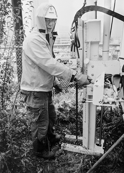
DLZ is expanding its’ conventional drilling capabilities with a compact, multi-function Geoprobe drill rig. Our new, all-terrain mounted drill rig, a Geoprobe 3126GT, broadens our subsurface investigation abilities. Although small in size and weight, the new rig allows us to access locations our larger and heavier rigs could not easily reach. Its articulated mast gives us the ability to drill on uneven terrain or at odd angles, which would typically be difficult with a conventional rig. Equipped with numerous safety features, including an inline drilling system to eliminate aligning the automatic hammer over the drill rod, a common pinch point, the Geoprobe 3216GT comes packed with all the capabilities of our larger, conventional geotechnical rigs, but in a small package.
CONE PENETRATION TESTING
For over 50 years, DLZ has offered traditional auger and mud rotary with standard penetration test (SPT), undisturbed tube sampling, piston, and Dennison sampling, as well as NQ, HQ, PQ wireline, and conventional rock coring. We are delighted to bring state-of-the-art, wireless Cone Penetration Testing (CPT) (ASTM D5778) to our subsurface investigation offerings. The CPT system is used in conjunction with our conventional drilling to rapidly characterize subsurface conditions and estimate the geotechnical parameters of the materials in the subsurface. The rig is factory equipped with integrated CPT head-feed rate controls and cone overload protection. It has a maximum of 36,000 pounds of downforce and 48,000 pounds of retraction force. The operator uses a laptop computer to monitor and collect the CPT data, including cone tip pressure, sleeve friction, pore pressure, and tilt angle from the CPT tool string. The rig can also add sensors like seismic or other geo-environmental logging tools.
A MAINSTAY OF ENVIRONMENTAL SAMPLING
After 20 years, we are very excited to announce that Direct Push (ASTM D6282) sampling is back at DLZ. This drilling method is a mainstay of environmental sample collection. Fast and efficient, Direct Push sampling has a small borehole diameter and generates no waste soil cuttings for later disposal. Plastic liners inside the tooling capture the soil and minimize the potential for cross-contamination of the sample. Additional capabilities include in situ discrete water sampling used to profile a groundwater aquifer and installing conventional monitoring wells and prepacked monitoring well screens through the tool string. We have several experienced Direct Push operators on our staff, including our first operator from 25 years ago.
After 20 years, we are very excited to announce that Direct Push (ASTM D6282) sampling is back at DLZ. This drilling method is a mainstay of environmental sample collection. Fast and efficient, Direct Push sampling has a small borehole diameter and generates no waste soil cuttings for later disposal. Plastic liners inside the tooling capture the soil and minimize the potential for cross-contamination of the sample. Additional capabilities include in situ discrete water sampling used to profile a groundwater aquifer and installing conventional monitoring wells and prepacked monitoring well screens through the tool string. We have several experienced Direct Push operators on our staff, including our first operator from 25 years ago.
DECADES OF DRILLING SERVICES
DLZ has provided geotechnical drilling services for a wide range of structures. With this new Geoprobe drill rig, we now maintain 11 drill rigs, various support vehicles, and equipment capable of providing most types of rotary, coring, and auger drilling throughout the Midwest.
We all know the importance of collaboration. Completing projects successfully in the fields of architecture and engineering requires working directly with other disciplines. Before COVID that was as simple as scheduling a face-to-face meeting with clients and disciplinary representatives.
COVID has changed the way we do things, ranging from mask-wearing and social distancing to no longer meeting in person. How do we maintain the same quality standards and collaboration levels as we saw before the outbreak started?
Within DLZ’s Architecture department, we deploy the following methods:
Zoom
Even before COVID, Zoom was making waves. This virtual meeting and collaboration tool features functionality for video conferencing, screen sharing, instant messaging, and audio calls. Many meetings that used to be face-to-face can now be coordinated through Zoom video conferencing. This still allows for speaker visualization using web cameras.
For non-meeting discussions between individuals, instant messaging provides a reliable form of communication. The quick screenshot tool allows users to take a quick shot of what they’re discussing for visual reference. Additionally, it provides a log of conversations that can be looked back at later.
One of the biggest accomplishments of Zoom is the ability to use it for remote teaching purposes. With offices spread throughout the Midwest, in-person teaching isn’t always an option, and with COVID it isn’t advised. Zoom allows experienced staff to work with younger staff members via video conferencing and screen sharing. This includes the ability to request and take control of someone else’s screen, minimizing the confusion of audio directives.
Zoom has become the primary replacement for in-person meetings during these times. Other software, such as GoTo Meeting, provide similar functions.
Microsoft Teams
Microsoft’s version of meeting and collaboration software allows users to create teams of individuals. These teams then have access to group chats and the ability to have meetings through the software. Much like Zoom, it’s possible to do calls and share your screen with other users.
Teams has other functions, such as a shared wiki, which is useful for project milestone tracking. This function also allows for the ease of tracking of team roles. There’s also a file share function that allows files to be shared solely with the team members. This is especially great for project coordination when files need to be shared with team members outside of the company.
BIM360
A service of Autodesk, BIM360 uses cloud hosting to store Revit models and other project-related files. This service allows members of outside companies to collaborate on the same file without outside partners needing access to a company server. The service is specific to the people added to the project, so other than administrators, no one else can access the file system, which keeps sensitive projects secure.
The benefits of working in BIM360 are numerous. First and foremost, it allows for direct collaboration between the disciplines as work is updated in real time. Conflict errors between disciplines are rarer regardless of whether a single file is being used or a system of files for each discipline is being used. Additional benefits include a faster workflow as everyone’s data is directly in front of you, and users can work from any location instead of having to be in an office with access to a company server.
BIM360 also allows outside users to view the 3-Dimensional version of files in a web browser, which is great for sharing progress with the owner. Another useful tool is the ability to use web software to track changes between versions. This is extremely helpful when a design change needs to be made to the plan, and the change requires additional work from other disciplines.
Conclusion
In today’s technologically advanced age, quality through collaboration does not have to go by the wayside. With the tools outlined here we can continue to function at the same high standards as we did before the COVID outbreak. These new changes, while different from what we’re used to, still allow the level of interaction necessary for punctual completion of projects with a focus on quality.
I had the opportunity to interview Tom Hessler for DLZ’s “Executive Spotlight”, a regular blog that goes behind the scenes to showcase DLZ leadership. While Tom is an accomplished Director in DLZ’s water practice, with more than 25 years of experience, he is also a talented musician.
We talked about his love of music and how his hobby continues to compliment his professional life. Tom reminisced about his early years, “My Dad worked for Firestone as a real estate manager and we moved several times while I was growing up. I was born in Syracuse NY, then moved to Boston MA, then to Upstate NY near NYC, Green Twp. near Akron, Ohio then finally landing in high school in Medina. Nothing was more “fun” than moving as a freshman in high school….that was a bit rough. Fast forward, I studied at the University of Akron and graduated with a BS in Civil Engineering in 1990.” Tom said.
When I asked Tom if music has always been a part of his life he shared, “I was fortunate to grow up with three older brothers, so I was exposed to a lot of classic rock greats like the Beatles, Stones, Led Zeppelin, the Who and Black Sabbath. I continue to love this era the most, but several 90’s bands like Soundgarden, Alice and Chains and System of a Down are also at the top of my playlist.”
“I started playing in a serious band back in Akron during college and have been playing for over 30 years. The current band “DT and the Shakes” has been together almost seven years and the lead guitarist is my best friend who started with me in 1989. I also played six years in the alternative rock band Trainwreck Radio with my neighbor who in a past life opened for Green Day and Urge Overkill.”
Tom grew up in a family that was not afraid to sing, he commented “I’ve always liked singing and my parents sounded pretty good when they did it so I figured I would give it a try. A couple of drinks to get started usually does the trick!” he added.
Recently, the virus has interrupted the Hessler DT and the Shakes performance schedule, but they are eager to get back at it. Before coronavirus, they got together every other week for a few hours. “It’s been hit and miss since March” Tom shared, “When you play with good musicians, we usually have a new song down after a couple takes. It’s a great way to relax after working all day.”
So when I asked Tom, “what is your best story as a member of a band?” he laughed. “Well, I can’t tell the best story in detail — but it was witnessed by several people from the Akron and Cleveland offices at the Highland Tavern……let’s just say there was an over enthusiastic dancer enjoying our rendition of “Schools Out”. Happy anniversary Tom and Marla Sisley!”
What venues do you play at? “We play at local clubs in the Cleveland, Akron and Kent area about once a month. We have only played once since the pandemic. It was an outdoor show which I like to call “Coronafest”, since over 200 people showed up and did not behave and follow the rules. I would say our best venue had to be the 2016 DLZ 100th Anniversary Party which was a blast. Thanks again DLZ for that!”
Are you married? Children? “I have been married to Elaine for 25 years this December (not sure why she puts up with me!). She is a professor at Cuyahoga Community College. I have one daughter Erin who is currently trying to attend Ohio University as a sophomore studying Environmental Geology. When I asked if Erin inherited his music gene he shared, “Elaine used to play trumpet and was a member of the Ohio State jazz band as an undergrad student. Erin not so much……” Other hobbies? “I enjoy playing golf, biking, skiing, kayaking, hiking with my dog Rosie, and travelling with my family. We have been lucky enough to travel to Australia, Iceland, Alaska, and most of Western Europe and the US over the years.”
“Lately there is no real typical weekend. The most excitement is having social distance parties with the neighbors. If a cornhole game breaks out, that’s living! Hopefully, the Browns will provide something to look forward to on Sunday this fall.”
As we wrapped up our time together, I asked, “what would you like your professional community to know about you?” He paused and went on, “Working for DLZ for over 25 years, I have been fortunate enough to work for several different design disciplines working on CSO tunnels and near surface connection structures, sanitary and storm sewers, major water distribution mains, local water lines, condition assessment and pipe rehabilitation, site improvements, roadway and bike trails, highway and pedestrian bridges, and construction administration and inspection. DLZ has provided excellent opportunities to grow as a professional engineer. Currently, I am the Northeast Ohio Director of Water Practice and really enjoy working for our water and wastewater clients. Along with being a Professional Engineer in several states, I am a licensed Surveyor in the State of Ohio.” And the curtain dropped.…..Tom was headed off to meet with his team on a current project.